THE ATHENAEUM
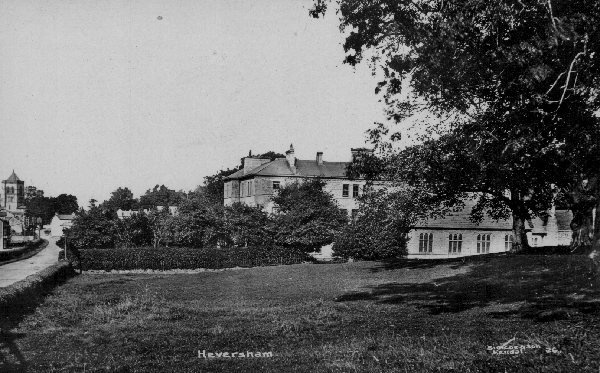
Heversham is probably unique in calling its village hall-situated at Leasgill - ‘The Athenaeum’. It takes its name from the Liverpool Merchants club to which the owner of the building Frank Atkinson Argles of Eversley belonged in 1872. The building is an eighteenth century barn, coach house and joiners shop which was tenanted during the mid nineteenth century by Richard Sisson - the forebear of the village’s longest resident family. Originally it seems to have doubled as a concert room where ‘Penny Readings’ were a principle attraction and a club house for non-alcoholic recreation. This included a reading room to serve as a haven from the overcrowded cottages. In time the Athenaeum became the venue for the village library and for every village organisation like the nineteenth century Eversley Lodge of the Freemasons, The Women’s Institute, Mothers Union, The Village Players, Old Time Dancing, Kent Estuary Young Farmers Club, Barnadoes Helpers League, Badminton club, the Snooker Club and Pool Table, in-door bowls, Welcoming and Farewell parties for successive vicars, Royal Events celebrations, private parties especially for children, wedding receptions, bazaars, rummage, bring and buy, table top and auction sales. During the Second World War, in the 1950’s and from 1965 to 67 and in the 1980’s and 1990’s the Athenaeum was used by the village school as a temporary class room and for longer periods as the dining hall for school dinners and as a dance studio for ‘Country Dancing’. After 130 years of daily use by every section of the community ‘t’athenaeum’ is probably Heversham’s best appreciated asset - even though hardly anybody knows how to spell its name.
The building has been adapted substantially on three occasions in 1927, 1970-75 and in 1999. Each alteration involved a change of entrance but the main hall still retains an excellent dance floor laid down in 1927.
HEVERSHAM GRAMMAR SCHOOL
Poor communications were probably the reason why Richard Watson, the son of Thomas Watson an eighteenth century Headmaster of Heversham Grammar School, said that in Westmorland there was a ‘grammar school under every hillside’. Heversham Grammar School was founded in 1613 by Edward Wilson of Nether Levens, the ancestor of the Wilsons of Dallam Tower. His dual aims were the ‘promotion of (the Protestant) religion and good learning’. The original schoolhouse - now derelict - still stands on Heversham Head and part of the original landed endowment including the school’s playing field at Tristrams continues to belong to HGS’s successor school.

|
The Old Grammar School on Heversham Head photographed about 1900 and
showing marks left on the front wall when the porch was removed to the garden
of Plumtree Hall where it became a summer house.
Please click on the picture to enlarge |
From its earliest years Heversham School catered for boarders whose homes were too far away from a school for them to be day pupils. Nevertheless the school’s most distinguished eighteenth century scholars were all day boys. They were Richard Watson who became Bishop of Llandaff and also Professor of Chemistry at Cambridge, William Preston who became Bishop of Ferns in Ireland and Ephraim Chambers. Ephraim was born at Wathsutton in Preston Patrick but after going to London he set himself up as a printer where he brought out ‘Chamber’s Encyclopaedia’.
|
Via Dolorosa - a scene of dread especially for Boarders.
The new Heversham Grammar School c.1910 showing the Boarding House of 1876 and `Big School' of c.1900. Please click on the image to enlarge |
Because the living of Heversham Church belonged to Trinity College the school enjoyed good connections and several scholarships to the University of Cambridge which contributed to the school’s enjoying - in most periods - a high reputation for academic education.
Around 1800 in common with other formerly ‘ Free Grammar Schools’ like Sedbergh and Rugby there was an attempt to transform Heversham into an exclusive fee paying boarding school and for much of the nineteenth century it was advertised as a ‘Public School’- meaning a private one! By that time Heversham’s position on the stagecoach route and, after 1846, its proximity to a main line railway station at Milnthorpe helped attract boarders. A move down from Heversham Head in 1876 to a large, austere building in the village street (designed by Joseph Bintley) was prompted by the need for more boarding accommodation. Day pupils continued and many Kendal pupils by-passed their town’s grammar school to travel to Heversham each morning on the Furness railway’s ‘Kendal Tommy’ or (from the 1920’s) the Dallam bus service and (from 1950) on the Ribble buses.
|
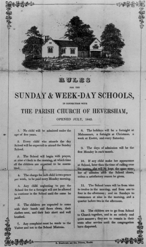
Opening Prospectus for Heversham Church of England School 1842
showing the School on the left and the School Cottage on the
right with basic rules below.
Please click on the image to enlarge |
More ‘bus boys’ attended as a result of the introduction of the 11+ in 1944 which provided free education for brighter local day boys. Despite extra day pupils Heversham Grammar School was threatened with closure until extra boarders were attracted in the mid 1950’s.
As a result the school continued to ape the Public School ethos of sadistic philistinism based on the already anachronistic inanities of the playing field and cadet force which, at the time, were extolled as being ‘character forming’. A social apartheid prevailed and as late as 2000 one former boarder of c.1960 referred to his day boy contemporaries as ‘peasants’. Certainly the day boys had their ‘school dinner’ in a ‘canteen’ while the boarders ate a segregated – though gastronomically even more vile - ‘lunch’ in a ‘dining room.’
The school’s regime became more humane during the later 1960’s but a persistent emphasis on its boarding side may have contributed to few local voices being raised in a ‘Save our Grammar School’ campaign prior to HGS’s being merged with Milnthorpe Modern School to become Dallam School in 1984.
Even so it was the Grammar School that caused the name of Heversham to be far better known than the names of similar sized villages. Moreover, after an uneasy start in the early Comprehensive years, Dallam School seems to have resurrected the old Grammar school’s reputation for ‘good learning’.
HEVERSHAM CHURCH OF ENGLAND SCHOOL
The school was founded by James Gandy in 1838. His initials and the date are carved on the south gable of the Old School which is situated on the northern edge of the Church Yard. The Old School Cottage (next door) was built by Mary Howard in 1841 and her initials and that date are on its gable. Because of squabbling amongst the benefactors and the church authorities the school did not open for several years after it was built.
It provided a basic elementary education with much scripture for girls and boys up to the age of about 12. It was not used by middle class children who attended various private schools situated in the village or at Milnthorpe. After a diphtheria epidemic and ‘an outbreak of typhoid amongst the infants’ in 1890 the school was condemned as unhygienic. The school’s Privy was built above St Mary’s Well, the village’s main water source!
The School then transferred to newly built premises at High Field, Leasgill which were opened in 1891. With the raising of the school leaving age to 13 in 1902 and 14 in 1918 numbers increased but from c.1920 older boys transferred to either Levens School or Milnthorpe Boys National School. All its teachers were women until 1967. The longest serving head was Miss Nancy Wright head mistress from 1937 to 1967. She had to cope with a fluctuating influx of evacuees during the Second World War and with the demands of the 11+ after it. Because most of the private schools in the area had closed after being declared ‘inefficient’ under the 1944 Education Act the school began to attract other - mainly middle class - children from surrounding villages. This helped the school achieve an above average success rate in the 11+ examination- known ‘at Leasgill’ as ‘The Scholarship’. Though condemned by inspectors for its ‘over formal regime’ in the 1940’s and 1950’s this continued. For most of the last half of the twentieth century 50% of the school’s pupils came from outside the Parish. In every OFSTED inspection and SATS tests the school was shown to be in the ‘top’ percentages for achievement by both County and National Standards.
The school was extended in 1903, in 1966 and in 1999. In 1999 the governors changed the official name to St Peter’s C. of. E. Primary School but the old Heversham C. of E. name is still on the school’s entrance notice board and on official County Council documents. Older former scholars usually speak of ‘having gone to Leasgill’.
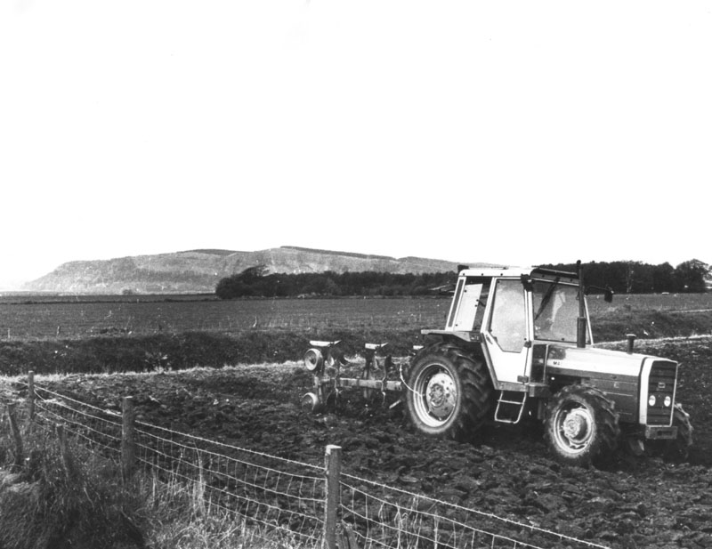
AGRICULTURE
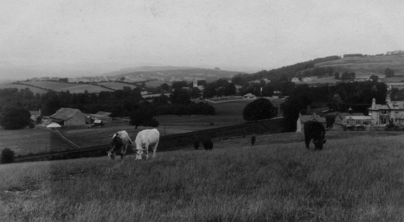
Agriculture has helped mould Heversham’s landscape and it has also been affected by it. The parish’s limestone based higher land is covered with glacial boulder clay on which grows the region’s prime crop-grass. Permanent pasture in all human ages provided the basis for stock farming. In c.1900 there were said to be 10,000 sheep in Heversham Parish; even so cattle especially, shorthorns in the nineteenth century gave the Parish a claim to agricultural fame.
|
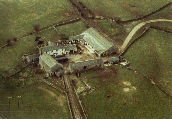
Greenhead Farm photographed c.1966.
In the late nineteenth century Shorthorns from William Handley's Greenhead herd won international renown. Please click on the image to enlarge |
Stock farming is indicated by 2000 cattle bones excavated at Watercrook. Records begin in 1335 when Alexander de Wyndesore accused William de Courcy of stealing ‘ 8 cows and 8 oxen at Heversham, in a place called Milnthorpe..’
Right down to modern times Heversham’s mixed marsh and upland terrain has caused farmers to follow a practice known as ‘transhumance’ which means the concurrent farming of ‘soft’ marsh land along with higher ‘hard land’. Thus Heversham farmers may cultivate lower arable and winter pasture meadows over a mile from their main holding ‘higher-up’ the village. To facilitate transfer of stock special tracks onto the higher lands were formed one of which- known as ‘Fluster Gap’ (on Woodhouse Lane)- conveys in its name something of the hustle and bustle associated with stock transference especially when their safety on the marsh was threatened by an angry tide.
FLOODS AND THE MARSH
|
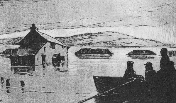
The Great Flood of 1907.
Illustration from Constance Holme's "The Lonely Plough" - rescue boats are approaching The Pride a fictitious farmstead based on Waterside, College Green and Halforth. The building resembles Halforth which historically was not touched by the flood. Please click on the image to enlarge |
For a thousand years the marshland provided Heversham’s with its main common grazing land a reference to which is contained in the name of Ninezergh, a farm on the edge of the Marsh (and also of Sizergh castle two miles to the north) - for ‘ergh’ is old English for summer pasture. By the eighteenth century marsh grazing was seen by advanced agriculturalists as being uneconomic. One of the leading pundits was a native of Heversham Richard Watson who as well as being a largely absentee Bishop of Llandaff was also a member of the very first Board of Agriculture. In 1799 he reported of his native heath- ‘near the mouth of the River Kent there is a marsh of considerable extent at Heversham and Milthrope (sic) overstocked but if the sea was banked off it would produce corn lands or if reasonable stint would enable better stock to be produced’. Partly as a result of his pleadings the major landowners succeeded in building a two and half miles long banking to protect newly enclosed and drained farmland.
|
Heversham Marsh-the land of "The Lonely Plough". Michael Barns is
ploughing close to the Brick Pond Field. In the background is the blunt bulwark
of Whitbarrow Scar.
Please click on the image to enlarge |
But the banks did not always hold. When breached Heversham suffered or enjoyed some of its most exciting moments. Often an uneasy and literally ill natured alliance of high tide and equinoxal gales has surged up the Bay to meet – perilously near the bank top - the waters of the Bela and Kent swollen by heavy rains. In the new year of 1831 the banking broke near Fishcarling Head and the inrush of waters was so forceful that Captain Greenwood’s ship the ‘Isabella’ was driven aground below Mosside Farm.
The same bank broke during the Christmas floods of 1852 when within ‘two hours the tide had overflowed the whole marsh extending betwixt Milnthorpe and Lyth several feet deep.’ Over at Foulshore Alexander Webster’s farmhouse was all but battered down and his parlour table was washed up on the Strands at Milnthorpe. Other lesser floods occurred in 1902 and 1903 but the ‘great one’ was the Mothering Sunday flood of 23rd of March 1907. Charging in from a series of breaches the tide engulfed Halforth and swept into College Green farm house reaching almost the floor of the bedroom where the farmer 84 year old Mr Lancaster was bed fast. Lancaster lost 59 lambing ewes and Mr Barnes at Parkhouse 36 sheep plus almost all their turnips and winter crops.
Constance Holme.
The events of the 1907 provided the setting for ‘The Lonely Plough’ by the Milnthorpe popular and ‘purple’ - novelist Constance Holme who expounded ‘the sea was always there and though it came quietly perhaps inoffensively there would be many a night when it would come like a beast of prey, ravening its path between narrow shores, devouring the watery desert’.
Later Floods.
After 1907 the sea wall was strengthened and a hedge along it which had harboured rabbit burrows grubbed out. Even so the bank broke again during ‘the war floods’ of 1917 and again in 1927 when Mr Nelson at College Green and Mr Bennett at Halforth each lost 18 sheep. Thereafter, thanks to routine maintenance by the Lancashire River Board and a major rebuilding of the banks following the east coast flood disasters in the 1950’s prevented major disasters. But in 1977 a long stretch of banking was swept away at Fishcarling with other gaps forced at Halforth and College Green. The waters swept inland almost as far as Heversham Hall and a fish was found on the roadway just below Mosside Farm. Subsequent strengthening with stone and brush wood bulwarks succeeded in keeping the Bay at bay though the banks broke at Waterside in 1994 and in 1997. Consequently there lingers always in the back of the marsh farmer the fear that a single furious tide could destroy the work of a season or even a lifetime.
BATHING
The strengthening of the sea wall along the estuary closest to the village had the effect of removing what in earlier times had been a popular bathing beach - although its sand was merely river mud. South Westmorland had been touched by the late eighteenth century discovery of the seaside and in 1814 the vicar of Heversham Dr Lawson said that a church should be built at Milnthorpe because it ‘was much resorted to during ye bathing season by the multitudes around’. Similarly Plumtree Hall at Heversham when put up for sale in 1823 was advertised as being ‘about one mile from excellent and convenient SEA BATHING’.
The bathing was never safe and some of the saddest epitaphs in Heversham Churchyard record drowning tragedies. Perhaps the most tragic is to " Jane the loving and beloved wife of Mr John Dickinson of Milnthorpe. She departed this life April MDCCLXX (1770) aged 43 years. As also Four Children Agnes, Richard, Elizabeth, Birbeck drowned in Bathing on the Sands 10 August 1770’.
A tablet in the Church commemorates ‘John Hudson second son of Robert Hudson Esq., of Tadworth Court Surrey and also Issac Hudson of Long Sleddale his School fellow who were drowned bathing on the Sands, 24th June A.D. 1792 both aged 16 years’.
In the northern church yard a cross ‘set up by their school fellows’ marks the grave of George Cowell of Lydgate aged 18, here buried Edmund J Goodwin of Manchester aged 19 and T M Rigby of Chorley aged 15, drowned while bathing on the sands August 30th 1855’.
HEVERSHAM HEAD
Heversham Head is the village’s main upland feature and forms its north eastern backcloth .It too was shaped by Ice Age. Though composed of carboniferous limestone it resembles a boulder clay drumlin with a longer northern slope (currently thickly wooded) and steeper southern slopes descending in a series of terraced steps created by the scouring effect of the ice. These ‘steps’ in the Estate Agents parlance command a glorious panorama of the estuary and the wider sea glimpsed beyond the engulfing hills of Arnside Knott to the south east and Humphrey Head which terminates the serrated edge of the Cartmel Fell range to the west.
|
Heversham in 1920 - photographed from Milnthorpe Hill. To the left is Parkhouse
Farm; to the right is St. Anthony's House. In the background may be glimpsed
Fairmead surrounded by an extensive garden wall whose stone was culled from
an adjacent quarry.
Please click on the picture to enlarge |
Northwards from the same view point the dyke diapered, tree flecked, levels of the Lyth Valley swelling out from below the blunt bulwark of Witherslack Scar may also be scanned while to the east protrudes the bald egg of Farleton Knott, another reminder of the limestone bedrock. Because of these views the lower meadows on the Head fronting Woodhouse Lane provided ideal building sites in the first half of the twentieth century.
WATER SUPPLY
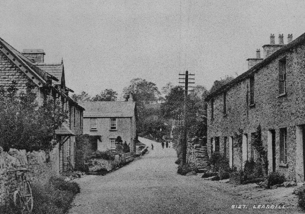
For most of Heversham’s history the higher land along Woodhouse Lane and much of the area covered by the modern village could not have been built on because of lack of water caused by the porous nature of the underlying limestone. As a result most of the village’s pre 1900 property is ranged along a spring line at the base of the hills which stretch for a nearly a mile from the appropriately named Spout House and Springfield south of the Church to the northern edge of Leasgill whose name literally means a place with a small stream (gill) below (or in the lea of) of a hill. In wet weather the original gill still trickles on to the road just north of West View Cottage though the ancient trough into which it once vented was moved a few yards northwards during building development in the 1990’s. Originally this gill helped fill a semi permanent pond below the eastern slopes of Haysteads until it was drained during the construction of the Princes Way.
|
Leasgill c.1900.
The original Gill trickled out just to the north of West View Cottage on the right. On the left are Strickland House, Rose Cottage and Yew Tree. Please click on the image to enlarge |
Apart from a few rills draining onto the marsh there are no streams in Heversham. The nearest running water is Deepthwaite Beck a mile to the east and the river Kent itself a similar distance to the west. Hence there were no water mills within the current village and the ancient parish’s industrial area was a mile south at Milnthorpe which at one stage possessed eleven water mills on and around the Bela. Another ancient mill was at Viver just over a mile to the east where traces of earthworks for the mill pond can still be seen.
Lack of water for both domestic and industrial purposes therefore contributed to Heversham village being comparatively smaller than other places within its ancient Parish. It may also have led to a class distinction between the workaday people of Milnthorpe and their more rural and- from at least the nineteenth century onwards- their avowedly more ‘genteel’ neighbours over the hill at Heversham! Traditionally Heversham folk have looked down on inhabitants of the larger village as being ‘scraggy’ (quarrelsome and poor) while Milnthorpe retaliated by calling Heversham folk smug and servile. So, the historic name calling between the villages may have a geographical cause!
Despite its damp climate and soggy terrain Heversham’s water supply was poor as its wells were prone to dry up in the summer months. Wells and pumps known to have existed around 1900 were situated- starting from the south of the village- at Spout House, two at the Grammar School (now the VI Form Centre of Dallam School), Church Farm, behind Chestnut House, Heversham House, the Eagle and Child, behind the old Grammar School on Heversham Head, St Mary’s Well, Plumtree Hall and Croft Farm at Leasgill.
Leasgill was particularly badly supplied and old photographs show that almost all the cottages had water butts to collect rain water. Around 1900 the chatelaine of Eversley House Mrs Tom Argles arranged for water to be carted from a horse pumped field well (opposite the Eversley entrance gates) to a tank behind the Athenaeum on Leasgill’s ‘low road’. Eighty years later older residents were a still extolling Mrs Argles’ magnanimity even after they were informed that Mr Argles had had hot and cold running water laid on in his stables a good half century before most of his tenanted cottages got modern sanitation.
Heversham’s public well known as St. Mary’s Well still exists by the roadside on the northern edge of the Churchyard. It is said never to have run dry and may have been the focus for an original Pre-Historic settlement. Until the 1950’s water was drawn from it for black Galloway cattle pastured in the field where the Crow Wood council were built in 1952.