
|
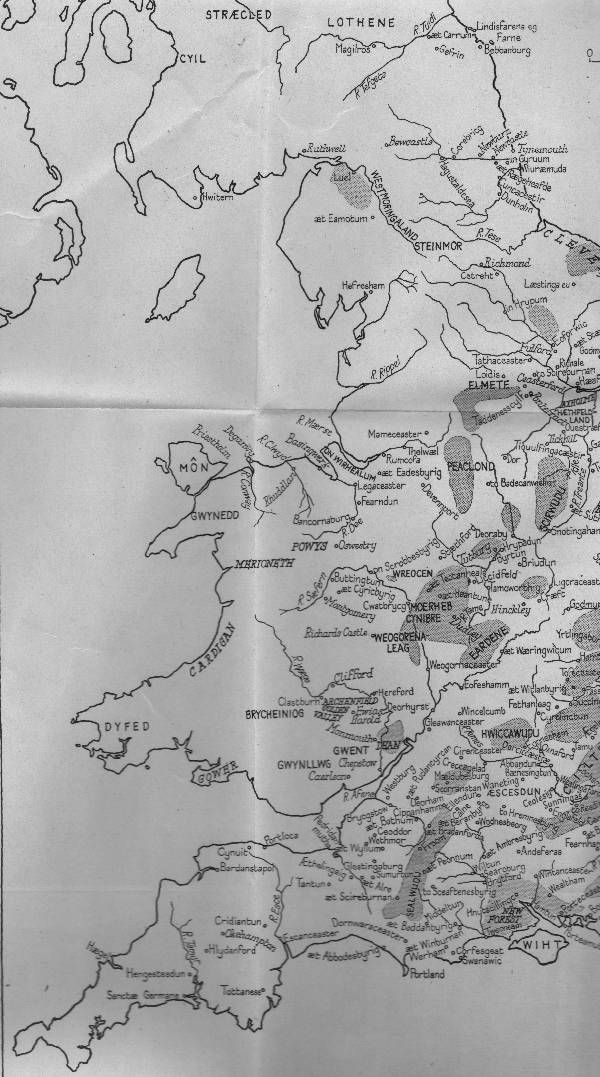
The North West of England about 900AD - from Anglo-Saxon England by F M Stenton,
Oxford History of England Series 1947.
The map shows Heversham's select status as one of the few named places recorded in the North West during the Dark Ages. Please click on the image to enlarge |
A PLACE IN HISTORY
Heversham is an historic and lovely place. Its history, therefore, may be surveyed within the context of its geographical setting.
If the definition of ‘history’ is the study of the recorded past it deserves, also, a prime position in the life story of the North of England. Heversham is the only Cumbrian place name, still recognisably in use, that has come down to us from the so called Dark Ages; for as ‘Hefresham’ it is mentioned in the tenth century ‘Historia de Sancto Cuthberto’. Hence on the map of Anglo-Saxon England in Stenton’s Oxford history only ‘Hefresham’, ‘aet Eamotum’ (Eamont Bridge) and ‘Luel’ (Carlisle) are recorded in Cumbria. ‘Mameceaster’ (Manchester) is the nearest place recorded to the south.
|
The North West of England about 900AD - from Anglo-Saxon England by F M Stenton,
Oxford History of England Series 1947.
The map shows Heversham's select status as one of the few named places recorded in the North West during the Dark Ages. Please click on the image to enlarge |
NAMES
Nearly a thousand years before the ‘Historia’ was compiled scores of geographical features, forts and towns situated in what later became North West England were inscribed on Roman ‘Notita’. But because of conflicting sources their names are conjectural. Thus Morecambe Bay, at whose head Heversham is situated, derives from a Latin name originally given to ‘Moricambe’ Bay an inlet on the Solway Firth eighty miles to the north while the ‘real’ Roman name for ‘The Great Bay’ itself has been lost. According to one ‘itinerary’ the Romans called their fort situated at Watercrook, (five miles north of Heversham), ‘Concangium’; other authorities speculate that it might have been ‘Alione’ or ‘Medibogodo’. Similarly the major Roman base sixteen miles down the Bay at Lancaster might have been ‘Ad Aluna’ or alternatively ‘Longovicium’. Hincaster, a hamlet two miles to the north of the modern village of Heversham and still contained within Heversham’s ecclesiastical parish, bears in its ‘caster’ ending the traditional appellation given by the Anglo-Saxons for Roman remains. Typically, however, neither tangible evidence nor Hincaster’s original ‘Roman’ name have survived but for over a thousand years Heversham’s identity has been clear.
SPELLING AND USAGE
Inevitably, down the ages, the spelling of the name has varied. Two hundred years after ‘Hefresham’ appears in c.900 in the ‘Historia’ it was registered in the Domesday Book as ‘Evesham’. In 1200 the spelling was ‘Euresheim’; in 1220 ‘Eueresham’; in 1302 ‘Heveresham’ and in 1316 ‘Heverseym’. The modern spelling appears in 1318 when ‘Ranulf son of William de Wyndesore of Heversham in Kendale grant(ed) to William son of Ranulf Payfoote a dwelling in Astenthwhate’ (Ackenthwaite).
Later variants include ‘Eversham’, ‘Eversham’, ‘Hevsham’ and – as late as 1700 - ‘Hearsham’. By and large the name of ‘Heversham’ as coined in the fourteenth century has stuck and in this respect Heversham is unusual.
The name of Milnthorpe, which was always the largest community within the ‘old’ parish of Heversham, only became standardised at the end of the nineteenth century. Thus its spelling ranged through ‘Milnethorp’ in 1380, ‘Milnethorpe’ in 1541, ‘Myllthrope’ in 1669, ‘Milnthrop’ in 1661 and ‘Milthrop’ in 1713. Perhaps the flexibility of Milnthorpe’s spelling is because it is a difficult name to say which accounts also for its being commonly pronounced as ‘Milanthorpe’ or ‘Milthrop’.
‘HEVERSHAM’
Few people have problems in pronouncing Heversham. In the 1950’s a Ribble Bus conductress used to cry ‘Heavens Home’ and occasionally broadcasters have referred to ‘Heeversham’ as if to rhyme with leaver rather the correct usage to rhyme with never. As in other places with the ‘ham’ ending e.g. Birmingham the ‘ham’ is pronounced as ‘um’.
The source of the terminal part of Heversham is easy to establish as it is derives from ‘ham’ or ‘heimr’ being the common word for a farmstead as spoken by several Scandinavian tribes including the Angles who penetrated the Heversham area between c.600AD to 700 AD. This was a century or so after their twin tribe the Saxons had settled in southern and eastern England. Traditionally the ‘Hever’ part of the name derives from ‘Haefar’ a personal name perhaps of the Angle chief who led the first immigrants. Alternatively the name might derive from ‘eofor’ which is old English for wild boar, a species known from archaeological and recorded evidence to have been common in the area until c1400 when according to legend the last local wild boar was killed either at Crook close to Windermere, ten miles from Heversham, or at Wild Boar Fell near Kirkby Stephen twenty miles to the east.
The Romans and the Angles were the first inhabitants of the area to leave written and place name records of their existence in northern England but they were neither the first nor the last invaders to leave a permanent mark on the region’s culture and language. Before them came 10,000 years of human activity which, because our knowledge of these millennia is not based on written records, are called Pre-historic Times.
THE ICE AGE
No evidence of the earliest humans belonging to the 100,000 years of the Old Stone Age has been found in the area. The Pre-historic story must therefore, start with the closing stages of the last great ice age –in Neolithic or New Stone Age times.
It was the successive advance and retreat of glaciers that created the landscape by eroding the uplands and depositing the resulting debris to overlay the lowlands. Heversham’s dual relationship with its contrasting high and low terrain has in all subsequent eras cradled its development. Around the Bay the deposition of glacial fallout formed drumlins and moraines two of which Haysteads and Parkhill effectively block the view from the village of the Kent Estuary which here meanders through the mosses towards the final tidal reaches at Halforth, an ancient farmstead set on a curved ear-shaped headland known as ‘the lug’.
THE RIVERS KENT AND BELA
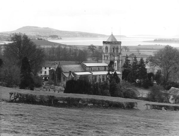
|
Heversham Church from Heversham Head- showing the Bela
(left) and Kent estuaries as they flow into Morecambe Bay.
The dented hill in the background is Arnside Knott, further in is Park Hill. To the right of the Church is Fishcarling Head and on the far side of the estuary Foulshore. The white mark across Park Hill had recently been made by excavations for the North Sea Gas Pipe Line.This photograph was taken by the Rev J. C. Hancock in 1984. Please click on the image to enlarge |
The Ice Age affected the course of the district’s two main rivers. The Kent meanders round Heversham’s western edge and the Bela which having skirted Milnthorpe enters the estuary at Summerhouse Point just beyond Heversham’s southern boundary. During the early stages of the Ice Age the sea froze to the north causing the water level in the immediate Irish Sea area to drop. This in turn led to the rivers cutting back along their original beds which in turn produced water fall ‘steps’ known as nick points at, respectively, Force Falls on the Kent and Beetham Mill on the Bela. These falls rendered both rivers un-navigable which meant that shipping had to anchor along the estuary from which practice the Port of Milnthorpe – the only one in Westmorland - originated. Heversham Force Falls prevented sea borne migrants from sailing further inland and so, perforce, they may have chosen to land on the grassy strands close to the present village.
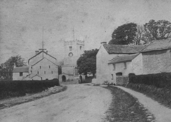
|
One of the earliest photographs of Heversham taken in the 1860's.
The photograph can be dated with some accuracy as it shows the Church Clock installed in 1860 and the Old Tower demolished in 1869. On the left is Chestnut House -formerly The Ship Inn. Its barn was demolished in c1912 and the site is now occupied by Tower House. Church Farm is on the right. Please click on the image to enlarge |
IMMIGRANTS AND SETTLERS
As the final Ice Age glaciers thawed away, the re-emerging coastal lands around the Bay would be as inhospitable as the tundra littoral of Antarctica and indeed there is next to no evidence that the area was inhabited at that time. When the climate warmed up the ground was covered by birch and willow and then by pine, oak, hazel and elm. At this stage the first hunters and gatherers would begin to approach the upper tidal lowlands. The discovery of a mass of Neolithic material at Heysham indicates a host community 15 miles away on the edge of the Bay around 5000AD. A flint scraper found at Watercrook and arrow and axe heads discovered only in the 1990’s in Levens Park prove that New Stone Age (Neolithic) people had arrived in the Heversham area by c.4000 AD and had begun to clear forests for agriculture. Analysis of soil deposits indicates a decline in tree pollen in mud deposits in former ponds c.3500 BC and a corresponding increase in grass seeds and grain.
As the New Stone Age began to merge into the first metal period The Bronze Age the climate became wetter and colder. It was at this time that the corduroy roads formed from tree trunks were laid down in the Lyth valley only a few miles from Heversham. At about the same time a relatively advanced Beaker People gradually moved up from the coastal area via the Kent estuary into southern Lakeland. Part of the Levens Park circular hut settlement may date from this time.
The succeeding Iron Age which evolved in North West England over a thousand years from c. 500BC to straggle the Roman period saw the immigration of the region’s best known Pre-historic tribe the Celts. Traditionally they are said to have come from Spain and may have sailed up the Bay in primitive craft . That they wished to defend the Bay coastlands from further ‘invaders’ is shown by a series of Iron Age Forts to be seen in the ‘clump’ at the top of Dallam Park and on Warton Cragg to the south of Heversham and at Heaves Fell and on The Helme to the north.
The first century Roman invaders called the warlike Celtic tribes the Brigantes –‘brigands’. Later descendants were called the ‘Cwmry’ from which the names Cumbria and Cumbrian stem. Locally the river Kent’s name could derive from ‘cam’ a Celtic word for a water course.
The Romans under Quintus Petellius Cerialis entered Kentdale around 84 AD having branched off from a major force associated with Agricola which had moved up the Lune Valley in the preceding seven years. Though Agricola’s son in law Tacitus claimed that native tribesmen guided the Romans across the Great Bay they left no archaeological evidence between their port at Lancaster and their fort at Watercrook. Similarly how Heversham fared in such incidents of Roman rule as the Pictish Conspiracy of 305 or the Barbarian Conspiracy of 367 (which did touch Cumbria) is equally unknown. Excavations at the Haverbrack Dog Hole do, however, prove that a Celtic/Cwmry community flourished near Heversham following the end of Roman rule after c.400 AD.
It was probably around 600AD that Angle settlers began to trickle into the area from across the Pennines. They were under the loose rule of the Kingdom of Northumbria but much of the Celtic – Cwmry way of life was probably untouched. When King Ecgfrith of Northumbria endowed a new church he granted it ‘the land of Cartmel and all the Britons with it’.
Place names provide permanent reminders of the Angles who first called southern Britain Angleland - England. Locally their ‘hams’ for farmstead are at Heversham itself and Beetham, with ‘tons’ for settlement (from which we get town) at Burton, Helsington, Hutton Roof, Casterton, Farleton, Dalton, Preston and Warton. ‘Circie’ the Angle word for church lives on as Kirkby Lonsdale and at Kirkby Kendal School. Above all the Northumbrian Angles called their distant trans-Pennine subjects – the ‘Westmoringas’ the people of the Western Moors from which stems the name of Westmorland.
THE VIKINGS
Around 900 AD South Westmorland was assailed by Norse Vikings who penetrated the area from Ireland and the Isle of Man. These Vikings unlike their ancestors who had first attacked England in the reign of Alfred the Great a hundred years earlier were probably Christian. Moreover, they seem to have settled relatively peacefully occupying previously vacant land. Their name for a settlement in a clearing was ‘thwaite’. Thus a short distance from ‘Angle’ Heversham there are ‘Norse’ Deepthwaite and Ackenthwaite. Their name for oats was ‘haver’ (from which also comes haversack) and for farm ‘flatts’ which has survived as Haverflatts Farm. The ‘thorpe’ place name ending found at Milnthorpe, Clawthorpe and Meathop indicates that these places were first occupied by Danish rather than Norwegian (Norse) Vikings. Both groups contributed to the region’s dialect which has a distinct linguistic identity. It was the Vikings who called the moors fells; the lakes tarns; the streams gills, becks and sykes; cliffs scars, hillsides bracks and slacks; cowsheds shippons; tracks gates and the marshes mosses.
THE MIDDLE AGES C.1000–1500
Around 1000AD Heversham was on a borderline between England and Scotland.
C1065 Heversham was part of the lands of Tostig brother of Harold II. Tostig was killed at the Battle of Stamford Bridge in September 1066 and Harold got the arrow in the eye at Hastings in October.
William the Conqueror’s Norman Conquest did not touch Westmorland though the Normans under Roger of Poitou crossed Morecambe Bay and took over Furness which became part of Lancashire across the sands until 1974.
Heversham as Evesham was entered in the Domesday Book under Yorkshire. Kendal and Kirkby Lonsdale both had Viking Lords at this time indicating the flexible sovereignty of the area.
1092 William Rufus conquered Cumbria and fixed the Anglo-Scottish Border at Carlisle. Westmorland became part of the English Kingdom.
In 1322 the Scots under Robert the Bruce laid waste much of Kentdale and taxation returns went down by two thirds as a result.
In 1497 Perkin Warbeck’s rebels invaded from Ireland but passed quickly through the area on the way to eventual defeat at the battle of Stoke.
MEDIEVAL RECORDS
| 1094 | Rufus granted Heversham and most other local Parishes including Kendal to Ivo de Taillebois. From then on South Westmorland became part of the Barony of Kendal as did e.g. Burton in Kendal. |
| 1094 | Ivo’s Gift Ivo de Taillebois granted part of the Manor of Heversham and the Church to St Mary’s Abbey at York. Heversham’s village well called St Mary’s Well refers to Ivo’s gift. The Remainder of the manor was retained by the Lords of Kendal and was inherited by the de Lancastre family who subsequently devolved it to the de Wyndesores whose name was given to Wyndesore Avenue in Milnthorpe. |
| 1120 | Chetel son of Eldred confirms grant of Heversham to St. Mary’s Abbey. |
| 1190 | Roger the Parson of Heversham witnesses a legal document. |
| 1210 | Gilbert Fitz-Reinfred and Helwise his wife confirm grant to St. Mary’s. |
| 1216 | William de Widlesores is a hostage of William de Lancastre, his wife’s uncle. |
| 1222 | William is released from imprisonment in Nottingham. |
| 1246 | Alan de Wasssand rector of Heversham is allowed to hold also the church at Mideltun in Yorkshire ‘by reason of his probity, knowledge of letters and … the multitude of people who resort to him’. |
| 1247 | Alexander de Wydesour sued for debt. |
| 1249 | Alexander sued by his overlord Roger de Lancaster for disloyalty and for not feeding Roger’s sergeant or doing homage. |
| 1281 | Peter de Kendal complains that William de Karliol had pulled down his house at Heversham. |
| 1282 | Roger Croyser given land in Heversham by Benedict Prior of St Bees. |
| 1294 | John Bradfoot claimed Robert de Rughale and Adam de Rynangs took away his goods at Heversham. |
| 1302 | Robert de Wessington (Washington) recovered land lately seised by default from Walter de Stirkeland (Strickland). |
| 1307 | Walter de Stirkland granted free warren in Heversham. |
| 1317 – 1318 | The de Wyndesores grant property in Astenwhate (Ackenthwaite) to William Payfoote and others. |
| 1320 | Alexander de Wyndesore accused of stealing sparrow hawk eggs from Roger de Clifford. |
| 1324 | Following Bruce’s Raid of 1322 Kendal records state ‘that divers burgages which ought to render 40s now render only 6s by reason of destruction by the Scots’ and ‘the water of Kent ought to be worth £4 but now only 40s’. Heversham probably suffered as much from the Scots at this time. |
| 1332 | King Edward II raises a subsidy tax on Heversham. People named include Alexander de Wyndesore, Thomas the cobbler, William Dausone, Thomas Scattergod, Robert Saul, Alexander Milner and Henry Belleson. |
| 1334 | Alexander de Wyndesore founded Milnthorpe Market ‘in Heversham’. |
| 1335 | The vicar of Heversham granted land by Alexander de Wyndesore. |
| 1346 | Pardon for Robert Croyser of Heversham for the King’s service in Normandy. |
| 1351 | The manor of Heversham held of William de Courcy by cornage, wardship and relief… |
| 1356 | Alan son of Hugh accused of taking corn worth 100 shillings belonging to John Cayrous. |
| 1363 | William de Wyndesour guilty of not finding 60 of the best archers for the King’s service. |
| 1365 | William de Wyndesour recruits 120 men for the King’s service in Ireland. |
| 1377 | Religious persons allowed to eat ‘flesh meat at William de Wyndesore’s table on lawful days.’ |
| 1380 | William de Chamber of Milnthorpe in Heversham sues William Hodggeson of Nateland and others for 100 shillings of debt. |
| 1428 | The Archbishop of York visits Heversham Church. |
| 1453 | Thomas Clyveland ‘late of Heversham’ pardoned for outlawry. |
| 1460 | William Archbishop of York grants the vicar of Heversham £60 pa and ‘a third part of the Mill at Milnthorpe and a tithe of lamb, wool, hay, fishings, foals, calves, pigs, brood geese, hens, ducks, bees, eggs, pigeons, line, hemp, leeks, onions and garden fruits of the whole parish..’. |
| 1482 | William de Redmayne left to the Church at Heversham ‘one cloak of damask silver coloured with which to make a cope….’ |
LATER RECORDS
| 1529 | Edmund Abbot of St Mary’s reorganised the tithes from the ‘parishynges of Eversham and Kirkeby in Kendale’. |
| 1534 | St Mary’s Abbey dissolved by Henry VIII. All Abbey property including churches at Heversham and elsewhere, Heversham Hall and the ‘Abbot’s Hall’ at Kendal confiscated by the Crown. |
| 1541 | Anthony Duckett transfered manor of Heversham to Lord Latymer. |
| 1557 | John Cowen in his will wished ‘to be buried in the churchyard of my p’ishe of Hev’sham among my elders at the East End of the churches’. |
| 1557 | King Philip and Queen Mary (Philip II of Spain and Mary Tudor/Bloody Mary) granted the advowsom of Heversham Church to Trinity College, Cambridge. This meant that the right to chose the Vicar belonged to Trinity College. The College also took over half the church land and accounts for College Green Farm on Heversham Marsh and College Meadows at Crosby Lodge, Ackenthwaite. |
| 1557-8 | Edmund Moyses, Richard Foster and Robert Bouskell took over the third part of the Manor ‘late parcel of the dissolved monastery of St Mary, York.’ |
| 1571 | Robert Bouskell held of the Queen in Heversham ‘ 6 cottages, 72 acres and all the works of the tenants on bond days’. |
| 1577 | Heversham manor assessed as being worth ‘£ 45 9s 10d and 38 hens..’ |
| 1583 | Queen Elizabeth recovered rights over Heversham Manor which included ‘100 messuages, 20 tofts with a mill, 100 gardens, 600 acres of meadow, 500 acres of heath and gorse, 1000n acres of pasture, 100 acre of wood, 200 acres of turbary (peat bogs) 20s. |
| 1586 | Edward Middleton of Leighton Hall granted a messuafe in Leasgill to Thomas Strickland of Nyanserghe (Ninesergh) in Leasgill for a yearly rent of 13s 4d . |
| 1594 | Sibbell Browne of Ev’sham in her will to : ‘Rychard Graveson my brother in lawe one cowe, to Bridget Dobson 4 pieces of puder and one chettle, a girdle, a candlestick and a cov’let. Rychard Graveson John sonne a brass pott. Janet Jackson 8d, Robert Cocks wif 2d, John Bacchus wif 2d, Edmund Browne one sheip’ etc. |
| 1597 | Thomas Bradley of Arnside sold the manors of Heversham and ‘Milthrop’ to James Bellingham of Over Levens (Levens Hall). |
| 1598 | The Plague 2,500 people were recorded as dieing in Kendal. This figure probably refers to the barony of Kendal which included Heversham. |
| 1601 | Fire at Heversham Church. The Vestry book recorded: ‘Wheras it fortuned through the negligence of a careless workman, being a plumber, anno christi 1601, on Wednesday being the first day of July, the Parish Church of Heversham, in the County of Westmorland was utterly consumed with fire with all implements, ornaments, books, monuments, chests, organs, bells and all other things perished’. |
| 1602 | Jasper Buskell conveyed Heversham Hall to Edward Wilson of
Nether Levens.
N.B. Edward Wilson was the ancestor of the Wilsons of Dallam who still own Heversham Hall. The current owner Brigadier Tryon-Wilson is the Lay Rector of Heversham Church by virtue of his possession of the Hall. The south-east corner of Heversham Church is called the Dallam Chapel because of this connection. Until her death in 1998 Eva Kilshaw daughter of a former Dallam tenant always sat in the Chapel while attending worship. Within living memory other Dallam tenants sat in the Dallam Chapel; its pews bear the Wilson crest of a ‘flaming crescent’. |
| 1613 | Edward Wilson founded Heversham Grammar School. The original foundation document has not been discovered – though it may exist in the Dallam archives or in the School’s records. The document of 1620 has survived and is sometimes quoted as the original Foundation Deeds. |
| 1620 | Edward Wilson confirmed his foundation of the Grammar School ‘out of zeale, goodwill and ingenious disposition wch he always heretofore hath hadd and now hath unto Religion, good learning and discipline and especially to increase, maintayne and continewe the same in the parish of Heversham wherin he liveth by the helpe of a good Schoole which he hath already there founded and sett on foote for the education of youth and to season their tender yeares with good principles….’ |
| 1623 | The Plague. The Parish registers showed 157 deaths compared to an annual average of about 20. The next highest mortality rate was in 1746 when 27 children died in Milnthorpe. |
| 1630 | Will of Richard Gibson of Rowell mentioned many field names: ‘Newlandes of the south side of Millthorpe Green, Crostonlaugh, Eskrigge Branside , Farrclose, Toddholes and Foggyholes’ all in ‘Aughtenthwaite’ (Ackenthwaite). Milnthorpe Green was a large common which stretched from Milnthorpe Green to Smithy Lane at Ackenthwaite. The Audland family home called since 1986 ‘The Old House’ was originally called Ackenthwaite Green House. Ackenthwaite Green occupied land on the east side of the Ackenthwaite to Woodhouse Rpad as far as High Cragg Yeat formerly called Bucks Yeat. |
| 1662 and 1669 | The Hearth Tax returns show that Mr Wilson at Heversham Hall had seven hearths, Mrs Duckett, James Murthwaite, Leonard Croft, Widdow Parke, had 3. Edward Barrow, Henry Preston, William Parker, Rowlande Parke, Thomas Cragg, Richard Bickhos (Backhouse?), Myles Dykinson, Thomas Sanderson, Myles Hynde, John Gregg, Mathew Addington, William Atkinson, Richard Cragg, Robert Beck, Thomas Kitchin, Mr Bellingham all had two hearths. Widow Dickinson had two but ‘1 walled up’. Other local surnames mentioned include Lister, Moone, Barker, Parker, Watson, Woodhouse, Cornthwaite, Garnett, Dowker, and Gueldart. |
| c.1694 | The Rev Thomas Machell visited Heversham and noted:
‘a fair parish church burned down to the ground about a hundred
years ago and now in very good repair’ and ‘it seems from the
well two hundred yards from the church called St Mary well
- that the church - be dedicated to the Virgin Mary, but the
rushbearing is on St Peter’s Day in Midsummer’.
NB The Church’s Dedication is not mentioned in old documents but from the nineteenth century the patron saint was clearly St. Peter. The confusion persisted at least until 1844 when the east window was installed showing St Mary in the centre upper light with St Peter holding his key to the side. |
| 1700 | Edward Wilson lays down fishing rights on Heversham and
Milnthorpe Marsh.
Evidence includes ‘he is lord of the water of Bethay (Bela), as he compelled two men that had been fishing in the river to enter into bonds with condition to forfeit the bond and pat penal sum if at any time they should ever fish there without his leave’. If land is enclosed the rent to be ‘if two pence to Mr Bellingham (of Levens) then a penny to himself (Mr Wilson). Also in 1700 an agreement of c1660 was confirmed that ‘for every boat that comes up the river pays four pence for unloading’. |